Walking Words: Hamilton House via Stokes Croft to the Unitarian and Bearpit

room 6 ECHOES

Location: Bristol, City Of Bristol, England, United Kingdom

Hamilton House to the Unitarian via Stokes Croft and the Bearpit

Poets: Pete Weinstock / David C Johnson
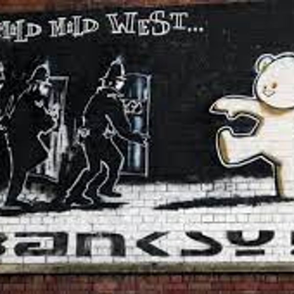
Stokes Croft

The road takes its name from John Stokes, mayor of Bristol in the late 14th century.His will recorded the area as "Berewykse Croft in Redeland", while the will of Nicholas Excestre, who died in 1434, named it "formerly John Stoke's close". It runs through the historic manor of Barton, which was recorded in the Domesday Book and part of the City of Bristol since 1373.

Stokes Croft was predominantly rural until around 1700, being mainly used for market gardening. Urban development was first logged in the parish records of 1678, while St James Square, to the west of Stokes Croft, was laid out by around 1710. John Roque's map of Bristol 1750 shows the area built up and running north of a central courtyard between Stokes Croft, North Street and Wilder Street. Though industries were established on Stokes Croft during the 18th century, the road was not fully developed and built-up until around 1850. Construction of the Carriage Works at No. 104 began in 1859, while the City Road Baptist Church was built in 1861. The area was damaged badly in World War II, with many buildings destroyed on Stokes Croft and King Square.

St James' Fair

St James' Fair was an annual fortnight of excitement, adventure and entertainment for the people of Bristol. Beginning in the 13th century in and around the churchyard of St James, it originally took place during the feast of St James at the end of July, but by the 19th century it was held during the first two weeks of September.

It attracted traders and shows from all across the UK and overseas, which included, according to the exhibitors list, wild beasts, waxworks, flying coaches, peep shows, a camera obscura, air bathing, a revolving panorama, dwarves, giants, and even 'a learned pig'. Traders sold goods ranging from earthenware pots to silk ribbons, and there were food and drink stalls, theatres, and fair ground rides. Bush houses, unlicensed pubs identified by an evergreen garland or bush, were also extremely popular until they were outlawed in 1815.


Walking Words
Walking Words
A poetry soundmap of Bristol UK

DOWNLOAD OUR APP TO DISCOVER THIS TOUR AND MANY OTHERS.

play-storeapp-store

The Echoes


The Turbo Island Dig

Poem by Pete Weinstock

The Unitarian

Poem by Pete Weinstock

Brunswick Graveyard

Poem by Pete Weinstock

Toby the Sapient Pig

Poem by Pete Weinstock

All the Fun of the Fair

Poem by David C Johnson

Background Music

5074 documentary by creativemediass

Discover more geolocated content in our apps.
play-storeapple-app-store

Or start creating tours, treasure hunts, POI maps... Just let your imagination guide you.


Other walks nearby

Misfits on the Move - Stokes Croft

Misfits on the Move - Stokes Croft

A short poetry walk with the theme of 'Identity' - from Hamilton House to The Bear Pit by The Misfits Poetry Group. We are a group of learning disabled people based at Hamilton House, Bristol
free
I Watch You as You Disappear 04/12/19

I Watch You as You Disappear 04/12/19

MA project
free
Walking Words: Bristol Beacon to Colston Statue Plinth

Walking Words: Bristol Beacon to Colston Statue Plinth

Bristol Beacon Past and Present / The Colston Statue and its history. Poets Pauline Sewards, Lisa Lopresti and Deasy Bamford Bristol Beacon The hall first opened as a concert venue in 1867, and was called Colston Hall as it was built on the site of Colston School named after Edward Colston an English merchant, slave trader, philanthropist, and Tory Member of Parliament. The name was changed in 2020 to become more welcoming and inclusive. The hall became a popular place for classical music and theatre. In the mid-20th century, wrestling matches were in strong demand, while in the late 1960s it developed into one of the most important rock music venues in Britain. ‘Hey! You Cats! I’m coming back’ From the UK Tour advert in March 1959 when the fabulous Louis Armstrong, in great form, played to a sold out Colston Hall in Bristol. It was reported he said ‘You sure are a jumping audience’ and in his dressing room Louis ate his lunch in his underwear. Beacon Hall was one of the most important rock music venues in Britain, hosting acts like The Beatles, Jimi Hendrix, The Rolling Stones, David Bowie, Elton John, Led Zeppelin and Pink Floyd. Its recent refurbishment, the first phase of Bristol Beacon's renewal in 2009 involved constructing the £20 million foyer space. Now remodelling the main hall to increase standing capacity by 15 per cent, transforming The Lantern facility area within the Hall into a versatile performance venue and opening up the extensive cellars for the first time in 150 years – creating a new performance space to be completed in 2023. Edward Colston The statue of Edward Colston is a bronze statue of Bristol-born merchant and trans-Atlantic slave trader, Edward Colston (1636–1721). It was created in 1895 by the Irish sculptor John Cassidy and was formerly erected on a plinth of Portland stone in a public park known as "The Centre", until it was toppled by anti-racism protestors in 2020. Designated a Grade II listed structure in 1977, the statue has nonetheless been the subject of controversy due to Colston's fortunes at least partially made from his involvement in organising the Atlantic slave trade, as a senior executive of the Royal African Company. The statue was erected to commemorate his reputation in Bristol as a philanthropist. From the 1990s onward the debate on the morality of glorifying Colston intensified. In 2018, a Bristol City Council project to add a second plaque to better contextualise the statue and summarise Colston's role in the slave trade resulted in an agreed wording and a cast plaque ready for installation. Its installation was vetoed in March 2019 by Bristol's mayor, Marvin Rees, who promised a rewording of the plaque which never materialised.(wikipedia)
free
Walking Words: Museum to Christmas Steps

Walking Words: Museum to Christmas Steps

A short walk from the Bristol Museum and Art Gallery down Park Row to the Christmas Steps. Poems by Gillie Harries The Museum and Art Gallery The Museum and Art Gallery's origins lie in the foundation, in 1823, of the Bristol Institution for the Advancement of Science and Art, sharing brand-new premises at the bottom of Park Street (a 100 yards (91 m) downhill from the current site) with the slightly older Bristol Literary and Philosophical Society. The neoclassical building was designed by Sir Charles Robert Cockerell (1788–1863), who was later to complete the Fitzwilliam Museum, Cambridge, and build St. George's Hall, Liverpool, and was later used as the Freemasons Hall. In April 1871 the Bristol Institution merged with the Bristol Library Society and on 1 April 1872 a new combined museum and library building in Venetian Gothic style was opened at the top of Park Street. Christmas Steps The name comes from the medieval Knifesmith Street. In Middle English the 'K' in 'knife' and 'knight' was sounded. It seems likely 'Knifesmith Street' became corrupted over time to 'Christmas Street'. In William Worcestre's 1480 itinerary of Bristol, he describes it as 'knyfesmythstrete aliter Cristmastrete' The street continued to be recorded as 'Christmas Street' in the official town rentals of the sixteenth and seventeenth centuries. This is also how it is recorded in the Hearth Tax Books of Bristol in the 1660s.Christmas Street still runs from St John's Gate to St Bartholomew's Hospital at the bottom of 'Christmas Steps'.(wikipedia)
free
Walking Words: Royal Fort to Wills Building

Walking Words: Royal Fort to Wills Building

A walk from the Royal Fort Gardens down to the Wills Building via Bristol Grammar School. Poets: Tony D'Arpino and Elizabeth Parker Royal Fort The house was constructed on the site of a Civil War fortification, which had two bastions on the inside of the lines and three on the outside. It was the strongest part of the defences of Bristol, designed by Dutch military engineer Sir Bernard de Gomme. It was one of the few purpose-built defensive works of the war era. The fort was designed as the western headquarters of the Royalist army under Prince Rupert. Royalists retreated into the fort when the Parliamentarians had broken through the lines in the siege of 1645, before eventually surrendering to Cromwell's forces. The fort was demolished around 1655. The "Royal" in the name was in honour of Prince Rupert, when he was made Governor of Bristol. Gardens Colonel Thomas Tyndall employed Humphry Repton from 1799 to landscape the gardens which form a small part of Tyndall's Park, which extended to Whiteladies Road in the west, Park Row in the south and Cotham Hill to the north.Over the years large parts of the park were sold for housing development, as the site for the Bristol Grammar School, purchased in 1877, and only a small part of the original area remains, as Royal Fort Gardens. The siting of drives in the Royal Fort park is still reflected in street plans today.
free
Walking Words: The Centre

Walking Words: The Centre

The Centre, past and present. Poet: Lisa Lopresti The course of the River Frome, immediately to the west of the historic centre, was covered over in stages, in the second half of the 19th century. The area became the hub of the city's tramway network, and was known as the Tramways Centre.[5] It was so called long after the last trams left in 1941, but is now known simply as The Centre. Between 1936 and 1938, the Centre was enlarged when more of the River Frome, between Broad Quay and St Augustine's Parade, was covered in, making way for the Inner Circuit Road.[6] The western side of the Inner Circuit Road has since been largely decommissioned, and recent works have rebalanced The Centre in favour of pedestrians, cyclists and public transport users. (wikipedia)
free
Walking Words: St.Johns Conduit-Brandon Hill down Park Street to the old city walls

Walking Words: St.Johns Conduit-Brandon Hill down Park Street to the old city walls

Poetry walk following St John's Conduit from St Georges down Park Street and across to the Bristol Beacon. Poet:Martin Rieser St John's Gate St John's Gate, which stands at the bottom of Broad street, is the last remaining part of the city wall, with Church of St John the Baptist built above it. The two side passages were created in the 1820s. Niches in the wall contain the figures Brennus and Belinus, according to legend they founded the city. Nearby St John's Conduit was originally built for the friary of the Carmelites but also supplied the people of Brandon Hill. The parishioners were allowed to use only the overflow from the system, and they took advantage of this again during the blitz of World War II when water mains had been damaged. (wikipedia)
free
Walking Words: College Green

Walking Words: College Green

Poet: Richard Devereux Description: A walk around College Green via Council House and Statue of Roy College Green The area around College Green has almost certainly been a place of religious significance for a 1,000 years. In 1140 a powerful local merchant Robert Fitzharding founded a monastery there, a community of Augustinian ‘canons regular’. By 1158–60 a church had been built in which to worship. A residential complex for the canons was constructed on one side of the church (west and south sides), and a burial ground stood on the other (today’s College Green). The two most spectacular survivors from this era are the Cathedral chapter house and the Abbot’s Gatehouse. They are among the finest works of 12th-century architecture in the country. The monastery was sited on high ground overlooking the rivers Frome and Avon, marking the historical gateway to Bristol. The church was embellished and enlarged during the 13th - 16th centuries. After the Dissolution of the Monasteries in the 1530s-1540s, the church at St. Augustine was saved and was made a Cathedral. This marked a transition from a monastic institution to a collegiate one (hence College Green), where a group of secular canons and priests are overseen by the Dean. It also marked the transition from an inward looking monastery to an outward looking, public institution. Bristol grew rapidly as England’s second city helped drive the colonisation of the Americas and the spread of the British empire. The former burial ground (now College Green) became an important public open space. St Jordan’s chapel became a schoolhouse before it was demolished, probably in the early 18th century. From 1868, under the architects GE Street and JL Pearson, the site of the medieval nave was cleared and the great cathedral nave built. The City Library was constructed from 1902-06 and the City Hall from 1935-52. Re-landscaping of College Green completed the transformation of the ancient sacred enclosure to the north of the church into Bristol’s premier civic space.
free
Walking Words: Queen's Square to Arnolfini

Walking Words: Queen's Square to Arnolfini

Poets: Liz Cashdan and Agata Palmer A walk around Queen's Square taking in Madame Tussaud and Kosciuszko, the Polish Patriot. The square was named in honour of Queen Anne, who visited Bristol in 1702, and it became the home of the merchant elite. It was conveniently placed for both arms of the harbour, but its low-lying position surrounded on three sides by a tidal river had disadvantages too: an 'assemblage of nastiness' floated in the river, and when the tide failed to carry this away it offended the eyes and nostrils of those living in the square. This was one of the factors which ultimately led the wealthy to the move up the hill to Clifton. Privateer Woodes Rogers lived on the west side of the square; a plaque commemorates this on the building that now occupies the site of his former home. Rogers circumnavigated the globe in 1707-1711, rescuing Alexander Selkirk (the inspiration for Dafoe's Robinson Crusoe) from Juan Fernández Island during his voyage. In 1831 Queen Square was the focus of a riot, in which half the buildings in the square were destroyed. The trigger for this was the arrival in Bristol of Recorder Sir Charles Wetherell, who misjudged Bristolians' support for some of his earlier positions to mean that they agreed with his opposition to the Reform Bill. There followed three days of rioting, looting and arson, fuelled by plentiful supplies of alcohol from the well-stocked cellars of residents, which were finally brought to a halt when Lieutenant-Colonel Thomas Brereton of the 14th Dragoons led a charge with drawn swords through the mob. Hundreds were killed and wounded and the mob dispersed. Brereton was later court-martialled for leniency because he had initially refused to open fire on the crowds, but shot himself before the conclusion of his trial. In the centre of the Square is an idealised equestrian statue of William III by John Michael Rysbrack, cast in 1733 and erected in 1736 to signify the city's loyalty.
free

Are you a creator?

START HERE

Privacy & cookie policy / Terms and conditions

© ECHOES. All rights reserved / ECHOES.XYZ Limited is a company registered in England and Wales, Registered office at Merston Common Cottage, Merston, Chichester, West Sussex, PO20 1BE

v2.4.30 © ECHOES. All rights reserved.