Chronicles - Walk 2

7 ECHOES

Location: Bangor, Ards and North Down, Northern Ireland, United Kingdom

John Witchell
John Witchell

This is the second walk of the Chronicles of Clandeboye (2.6 miles). A good starting point is on the A2 dual carriageway, and then walk the route in either direction. I suggest anticlockwise, taking you a short distance along the dual carriageway before turning left along the track to Meadow Way in Crawfordsburn. Then turn right and descend to the village. Cross the road and look out for the path leading into the Crawfordsburn Counrty Park, between the hotel and the Spar shop. Skirt the woodland until you come to the viaduct, then make your way left and join the main entrance road to the park. Follow this to the entrance at Bridge Road and cross over into the Towns' Womens' Guild wood. Follow the path over the hill and join the Clandeboye Avenue at Sunnybrook farm, Then turn left and follow the avenue all the way back to your start point on the A2.

An alternative route couldbe to start at Helen's Bay station and walk up the avenue to the dual carriageway and then back through Crawfordsburn, or start at Crawfordsburn.

Soundtrack: Orchestral Scherzo by Daniel Williams

Jan Mayen Clump

The earliest evidence of Lord Dufferin’s attraction to water was Lady Wantage’s recollection of him in Venice in 1851, “when he and Lord Gifford appeared on the Grand Canal in a small India-rubber boat, or rather tub, which freak on the part of the two mad young Englishmen caused much excitement among the people, accustomed to the calm dignity of gondolas.”[1]

Three years later Dufferin’s bravado extended to a voyage in his yacht the ‘Foam’ to the Baltic, where the English and French fleets were bombarding the Russian fort at Bomarsund, in the Aalund Islands. His escapades under fire are legendary as, in the words of Lyall, his biographer: “Like many imaginative men, he was evidently anxious to try the effect of inoculation with the war-fever, to test himself in situations that string up human energies to their highest tone, to witness the reality of what everyone reads about, and to feel the sensation of being actually under fire.”[2]

The next year he cancelled a trip to the Crimea when he fell ill. However, he made up for lost time in 1856 by setting sail for Spitzbergen, just 10 degrees short of the North Pole. His first landfall after Stornoway was Iceland, where he visited the Geysers, partied with Prince Napoleon, and captivated the Icelandic ladies.

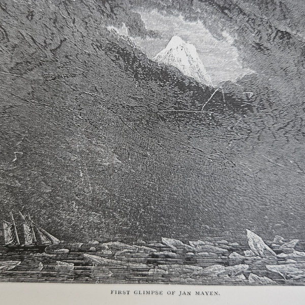
From Reykjavik he sailed in search of the mountainous dot on the chart called Jan Mayen Island. He was beset in an icy still calm by fog and ice, but eventually “the roof of grey suddenly split asunder, and I beheld the gap – thousands of feet overhead, as if suspended in the crystal sky- a cone of illuminated snow.”[3] After much maneuvering through the ice they finally reached the shore where they landed, carrying their discarded figure head, which he had replaced with Marochetti’s bronze of the Duchess of Argyll whilst in Stornoway, a white ensign, a flag-staff and a tin biscuit box containing a list of the crew and the name of the yacht. These they hauled up the mountainside where “having tied the tin box round her neck, and duly planted the white ensign of St George beside her, we left the superseded damsel, somewhat grimly smiling across the frozen ocean at her feet, until some Bacchus of a bear should come to relieve the loneliness of my wooden Ariadne.”[4]

Dufferin’s book ‘Letters from High Latitudes’, from which this passage was quoted, was a best seller. It is still in print and a joy to read. He even presented the queen with a copy, bound in driftwood from Spitzbergen.[5] 
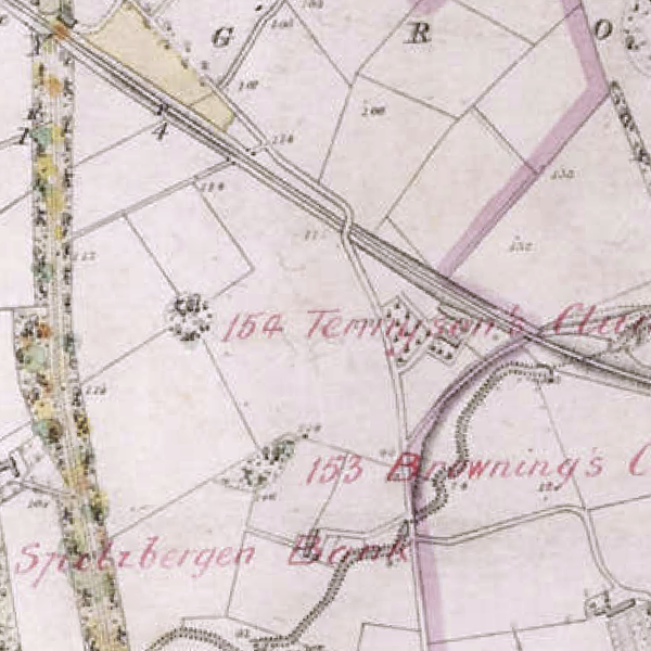
But I have almost forgotten the reason for these wonderful tales. Beside us, crowning the field, stands Jan Mayen clump.

[1] Sir Alfred Lyall, The life of the Marquis of Dufferin and Ava (London: Thomas Nelson & Sons, 1905), 75. [2] Lyall, The life of the Marquis of Dufferin and Ava, 87. [3] Lord Dufferin, Letters from high latitudes, ed. John Murray (1856), 121. [4] Dufferin, Letters from high latitudes, 126. [5] PRONI D1071/H/V/1/14 (27 August 1857)

1 sound

Ballymullan Townland

It was usual for ancient townland boundaries to follow watercourses, but here we have an exception. This lane marks the boundary between Ballymullan and Ballygilbert. It is clearly marked in Thomas Raven’s map of 1626[1] , although Ballymullan is not specifically named. Rather, it is divided into areas marked with the then occupier’s family names. The land adjacent to the Bangor side of the lane, and running all the way down to Crawfordsburn, was occupied by Danie Adams, and beyond that, as far as the Cootehall Road was occupied by Edward Baily. By 1712, these two parcels of land were possessed by the Blackwood family as shown on Sloane’s contemporary estate map.[2]

Of the three hundred and eighty-one acres occupied in 1712, eighty acres had been part of the original 1674 purchase of land by John Blackwood from Henry and Alice Hamilton, the Earl and Countess of Clanbrassil. The land purchase included the townland of Ballyleidy, now occupied by Clandeboye house and parklands.

The Blackwoods were merchants, and probably came from Scotland with the Hamiltons when they were granted a large part of what had been Con O’Neil’s land before the plantation of Ulster at the start of the reign of James VI &I. We know that John’s father was Provost of Bangor and, judging by his gravestone epitaph, well thought of. The family must have prospered because they were able to buy a large tract of land from the Hamiltons and build a comparatively large house with its own park. The first big house on today’s gold coast.

The purchase was just one part of the breakup of the Hamilton estate, the reason being most intriguing, and described in some detail in the Hamilton manuscripts, which I will draw on heavily.[3] It appears that Henry was not the marrying type, so when he was betrothed to Alice, Countess of Drogheda the family were delighted. However, she was particularly pretty and had extravagant tastes, that began to drain Henry’s resources. Things did not improve when she went to the court of Charles II, where there were rumours that she was tripping on Nel Gwynn’s heels.

Having miscarried their child and knowing that Henry had made provision in his will to leave his estate to his nephews if he should die without an heir, Alice prevailed on him to write a new will in her favour on the understanding that she would look after his estate and duly pass it on. He complied with her suggestion, despite his mother’s prophetic warning that if he signed it he would join his forebears in the family mausoleum within three months. The new will was signed on 27th March 1674, the land was sold to Blackwood on 22nd July 1674 and Henry died in suspicious circumstances on 12th January 1675.

Hardly surprisingly, the plot thickened, and hopefully I will find the opportunity in another narrative to explain how half of the Hamilton estate eventually ended up in the ownership of the Blackwood family.

[1] On display in the North Down Museum [2] PRONI T3666/1 [3] Lowry T E, The Hamilton Manuscripts (1867).

1 sound

Crawfordsburn

There is an understandable assumption that Crawfordsburn village was once part of the estate of the Crawfords, who occupied what is now the Country Park since almost the start of the Plantation in 1606. In fact, when the Blackwood family purchased land in Ballymullan at the beginning of the eighteenth century it included all the land to the south of the ravine at the back of the hotel. The burn, which crosses under the far end of the street, ran to the sea through the Crawford lands, hence the name of the village.

The Clandeboye estate lands, identified in the 1879 Declaration of Title included the Old Inn, the houses along main street, the Cottage at the far end, and the land behind them.

The Cottage, and the Old Inn were once owned by Mrs Reid, who sold them to William Johnston in 1910. He owned the Garden of Eden Bus Company that ran between Belfast and Crawfordsburn and proceeded to convert the Cottage into a tearoom called the Cingalee and built a ball room behind it. Unfortunately, Mr Johnston was later unable to renew the liquor licence for the hotel, due to its perceived attachment to the tea rooms. He was devastated by this and, losing heart, he closed them both down. It was only in the 1930s that Paddy Falloon took them on and eventually regained the hotel licence by creating the Country Club as a separate entity. And so, the two businesses parted, and each thrived until the 1990s, when the club became less fashionable, and membership dropped dramatically. The club first sold off the Cottage to local architect, Alan Cook who effectively rescued it from future development, because, in 2009 the decision was made to close the club and sell the remaining land for building, thus ending a century of social enterprise in the village. [1]

But there is another story, that led to the creation of a new social enterprise: In 1877 the houses on the South side of main street were let on 99-year leases. Later legislation provided for the purchase of the freeholds of long leases, but the owner of number 24 died in the 1980s without taking advantage of the provision.[2] This meant that the building reverted to the estate. Lady Dufferin did not want to capitalise on this windfall by selling the house so decided to offer a lease to the Camphill Community who converted it for use as a pottery and outreach for their students. More recently it was taken on by the Now Group, a social enterprise company that helps people with learning difficulties and autism and is now the successful Loaf Pottery and Cafe.[3]

The village is therefore fortunate that the Old Inn and the Cottage, both dating back to the beginning of the seventeenth century, are cared for and prospering, together with a new century of social enterprise at number 24.

[1] https://www.bangorhistoricalsocietyni.org/MEDIA/BROCHURES/CrawfordsburnCC.pdf

[2] Leasehold (Enlargement and Extension) Act (Northern Ireland) 1971

[3] https://www.loafcatering.com/cafes

1 sound

The Viaduct

You might assume that the sheer scale of the railway viaduct is testament to the level of support by the Sharman Crawford family for the Holywood to Bangor line. However, a letter to Lord Dufferin from his agent in the summer of 1862 hints at a different state of affairs when he wrote that the Crawfords may be interested in selling, and that “the railway company may purchase the whole estate and then sell off what is not used for the railway”.[1] Perhaps it was just rumour because work started on the line that year and by 1863 construction had started on the viaduct, with the ceremonial laying of the foundation stone by Major Crawford. He also deposited in a cavity a sealed bottle containing copies of the Belfast newspapers and some coins. These were removed for safekeeping by the park authorities in 1990 – still in good condition.[2]

Despite Sharman Crawford’s apparent enthusiasm for the new line and Lord Dufferin’s indifference, it is perhaps ironic that it was Dufferin who gained a station. Charles Lanyon, who designed the viaduct, intended to call it Crawfordsburn station, but Dufferin had other ideas and prevailed on him to call it Clandeboye station.[3] It was only later renamed Helen’s Bay station, as the village began to take shape. Crawfordsburn finally got a wooden halt in 1965, to serve what had become Crawfordsburn Hospital, but it closed again in 1997.

80 feet below the viaduct runs the burn after which the village is named. It was once valued as a source of power, with mills drawn on Thomas Raven’s 1626 map, both above the village and downstream of here. The first ordnance survey map of 1834 also shows ruined mills in the ravine at the foot of the waterfall. Although the Crawford estate may have owned the mills, the water catchment was in the Clandeboye estate, where there were also then two flax mills on the upper reaches, one on today’s Millbrook Lane in Ballysallagh and another that disappeared under Fraser’s parkland in the 1850s.

In 1899, Lord Dufferin was turning his attention to creating a piped drinking water supply to Clandeboye House and Helen’s Bay and had his eye on this burn as we can see from a diary entry: “In the afternoon Colonel Sharman Crawford came, and I walked with him to see the place from which we are going to take the water for the house, in order that he might see that we were not infringing his rights.” He then went a little further, hoping to increase the flow of water into his lake: “Also consulted with him as to whether he would object to our placing a dam in order to give us some of the water which runs from the cut down the Ballysallagh stream into the head of our river”.[4]

Luckily, they were good friends, to the extent that they even exchanged land to round off each other’s estate boundaries.

[1] PRONI D1071/A/K/1/B/11/1 (20 June 1862)

[2] Masefield. Robin, 'Be Careful, Don't Rush' (Bayburn Historical Society, 2015), 137.

[3] PRONI D1071/A/K/1/B/15/1 (25 March 1865)

[4] PRONI D1071/H/V/1/34 (28 April 1899)

1 sound

The Poet's Clumps

If you stand with your back to the entrance to Sunnybrook Farm you will notice a path leading into the wood that climbs the hill in front of you. This wood was sponsored by the Towns Women’s Guild and planted by the Conservation Volunteers. It was designed to link the avenue to the front entrance to Crawfordsburn Country Park, to make a pleasant walk back to the shore. At the top of the wood are the poets’ clumps of trees, now part of the new woodland. Browning’s clump is straight ahead, and Tennyson’s Clump is marked by the taller trees along the ridge to the left. They had written poems in praise of Helen’s Tower, dedicated by Lord Dufferin to his mother, and completed in 1850.

Tennyson was a particularly close friend, to the extent that Lord Dufferin was a pall bearer at his funeral in Westminster Abbey in 1892.[1] Tennyson’s is the most famous of the tower’s poems, and begins:

Helen's Tower, here I stand, Dominant over sea and land. Son's love built me, and I hold Mother's love in lettered gold.

Dufferin was so pleased with the poem that he wrote in an effusive letter to Tennyson that “You have indeed crowned all my Tower and all my wishes. Hundreds of years hence, perhaps, men and women, sons and daughters of my house, will read in what you have written a story that must otherwise have been forgotten…”[2] Prophetic words, as you will discover if you visit the tower and learn about its links to the sons of Ulster who marched towards the Somme in 1916.[3]

The recently restored Helen’s Tower stands ‘dominant over sea and land’ overlooking the southern end of the estate, five miles from here along the Columban Way footpath. Dufferin was a man who thrived on romance and chivalry, so it is not surprising that the poets are there, dominating this hill, to greet him when he returned from his travels.

At the pinnacle of his career, Lord Dufferin left Clandeboye in October 1884 for an audience with Queen Victoria at Balmoral before travelling to India to assume the role of Viceroy,[4] a position that he held until November 1888. He then travelled directly to Italy to take up the post as Ambassador in Rome.[5] After an absence of five years, he finally returned to Clandeboye in August 1889, and was met at the station by “the tenants and a number of other friends, who gave me a very warm reception, the tenantry accompanying me on horseback to Clandeboye House, where they presented me with an address, to which I made a suitable reply”.[6] By this time he had been elevated to the 1st Marquis of Dufferin and Ava.

[1] PRONI D1071/H/V/1/29 (12 October 1892) [2] Harold Nicholson, Helen's Tower (London: Constable and Co Ltd, 1937) 140. [3] Frank McGuinness 1985 ‘Observe the Sons of Ulster Marching Towards the Somme’ [4] PRONI D1071/H/V/1/22 (21 October 1884) [5] PRONI D1071/H/V/1/26 (10 December 1888) [6] PRONI D1071/H/V/1/26 (14 August 1889)

1 sound

Edith of Lorne

As you round this curve in the avenue, depending on which direction you are walking you will see a long straight road in one direction and the Red Bridge in the other. At one time this was the only route to the shore from the ancient road between Crawfordsburn and Holywood, now the Ballyrobert Road. In 1850, when Lord Dufferin walked to Grey Point with James Frazer, his landscape architect, “laying off ye avenue from ye sea to ye gate”[1] this road continued straight up the slope beside us to join the Ballyrobert Road. However, in order to create the avenue, Frazer re-aligned it towards a stream that ran under Ballyrobert road and built the bridge now before us, thus extending the new avenue under the road. But in the process the public road to the shore was cut off, so he made amends by laying out two new roads: Bridge Road and Craigdarragh Road.

On the other side of the avenue the Crawfordsburn river emerges through the woods from Edith of Lorne’s Glen and continues on its way towards the Crawfordsburn Country Park and the sea. But who was Edith of Lorne?

She may have been the Edith of Lorne from Sir Walter Scott’s poem “The Lord of the Isles,” in which Edith is betrothed to Lord Ronald, the Lord of the Isles, during Robert Bruce’s efforts to free Scotland from English rule (1307-1314). However, Ronald is in love with Bruce’s sister, Isabel. The story unfolds with Edith, disguised as a mute page, following Bruce and Ronald on their adventures and ultimately saving them from danger. Isabel discovers Edith’s true identity and gives her blessing to Edith’s union with Ronald.[2]

Or maybe he was referring to Edith, the daughter of the 8th Duke of Argyll. Her parents were close friends of Dufferin, who even commissioned the sculptor, Marochetti, to model the Duchess as the figure head for his yacht ‘Foam’ on his voyage to Spitzbergen in 1856. To quote from his diary, whilst in Stornoway before setting sail for high latitudes “Ashore looking for a blacksmith to put up our figure head. Great smell of fish. Wrote a letter to the Duchess of Argyll, little Edith’s picture opposite to me all the while.”[3] Although her title was Lady Edith Campbell, Lorne was a family name and her brother, the 1st Marquess of Lorne succeeded Dufferin as Governor General of Canada in 1878.

It's a difficult choice between his affection for his ‘little Edith’ Campbell and the Edith of his beloved Sir Walter Scott, about whom he wrote: “ I love Sir Walter Scott with all my heart; and my mother excepted, I think he has done more to form my character than any other influence; for he is the soul of purity, chivalry, respect for women and healthy religious feeling.”[4]

Perhaps I should just leave it to your imagination. [1] PRONI D1071/V/1/5 (26 October 1850) [2] Sir Walter Scott, The Lord of the Isles: A Poem in Six Cantos (1815) [3] PRONI D1071/V/1/13 (9 June 1856) [4] Andrew Gailey, The Lost Imperialist (London: John Murray, 2015), 24.

1 sound

The Rivals

In this section of the avenue the trees on either side of the path stretch a little further to form a woodland that Lord Dufferin named ‘The Rivals’ after the 1775 play by Richard Brinsley Sheridan, his great grandfather, and an important influence on his own lifestyle. ‘The Rivals’ was Sheridan’s first play, and the opening night was a complete flop, so he re-wrote parts of it and returned a week later with a box office hit, with the part of Mrs Malaprop causing great mirth. The now rather derelict clump of trees on the skyline to the East is named after her.

His wife, Elizabeth, may have had much to do with the play’s eventual success. Her beauty and exceptional soprano voice had brought her fame, and portraits of her were painted by Reynolds and Gainsborough. However, on marrying Sheridan in 1773, she left her career to support him in his expensive political and artistic lifestyle, which they hoped ‘The Rivals’ would subsidise.

Gainsborough’s portrait has a most remarkable biography. “The Sheridans were living next door to Lady Spencer, Squire Bouverie's mother, when a seizure was made by the Sheriff. Sheridan's servant knew the value his master set on this picture of his beautiful wife, and he managed to detach it hurriedly from the frame (a very large one) and to get it over the wall into Lady Spencer's garden. Poor Sheridan was glad to save the picture from his creditors, and leave it in his fiend's hands, from whom he got advances of money until he should redeem it. That redemption never occurred, and so it became Bouverie property.”[1] The Bouverie country seat was at Delapré, which is where we take up the story in 1862 with a letter from Joseph Hogarth to Lord Dufferin:

“On my arrival at Northampton on Thursday I sought Mr Rimer at his residence but had to retrace my steps and seek him at the house of General Bouverie, where he was said to be copying a picture for your Lordship…. As the additional labour is to a certain extent a new reading of the original I ought to see the pictures again before they are separated for, beautiful as the picture is, containing a landscape possessing all the largeness of Turner combined with that intermingling of golden colour upon silver lines so peculiar to Gainsborough…... It was only by a single stroke of the brush at the last moment he prevented the picture sinking into one of the pretty nonsensical shepherdesses of the Lely and Kneller school….”[2]

Whilst the copy still graces the gallery at Clandeboye, the original was sold to Baron Rothschild in 1872, for £3,000. In 1937 it was purchased by the Mellon Trust and donated to the National Gallery of Art, Washington DC, where it remains to this day.

[1] Diary of Mrs. Caulfield, wife of the second son of the first Earl of Charlemont (12 March 1872 [2] PRONI MIC22/16 (14 July 1862)

1 sound

DOWNLOAD OUR APP TO DISCOVER THIS TOUR AND MANY OTHERS.

play-storeapp-store

Or start creating tours, treasure hunts, POI maps... Just let your imagination guide you.


Other walks nearby


Are you a creator?

START HERE

Privacy & cookie policy / Terms and conditions

© ECHOES. All rights reserved / ECHOES.XYZ Limited is a company registered in England and Wales, Registered office at Merston Common Cottage, Merston, Chichester, West Sussex, PO20 1BE

v2.5.15 © ECHOES. All rights reserved.