Walking Words: SS Great Britain

room 3 ECHOES

Location: Bristol, City Of Bristol, England, United Kingdom

Poet: Marie Papier

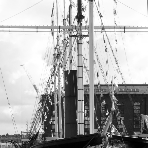
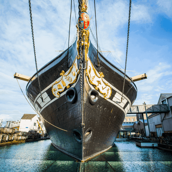
SS Great Britain is a museum ship and former passenger steamship that was advanced for her time. She was the largest passenger ship in the world from 1845 to 1854. She was designed by Isambard Kingdom Brunel (1806–1859), for the Great Western Steamship Company's transatlantic service between Bristol and New York City. While other ships had been built of iron or equipped with a screw propeller, Great Britain was the first to combine these features in a large ocean-going ship. She was the first iron steamer to cross the Atlantic Ocean, which she did in 1845, in 14 days.

The ship is 322 ft (98 m) in length and has a 3,400-ton displacement. She was powered by two inclined two-cylinder engines of the direct-acting type, with twin high pressure cylinders (diameter uncertain) and twin low pressure cylinders 88 in (220 cm) bore, all of 6-foot (1.8 m) stroke cylinders. She was also provided with secondary masts for sail power. The four decks provided accommodation for a crew of 120, plus 360 passengers who were provided with cabins, and dining and promenade saloons.

When launched in 1843, Great Britain was by far the largest vessel afloat. But her protracted construction time of six years (1839–1845) and high cost had left her owners in a difficult financial position, and they were forced out of business in 1846, having spent all their remaining funds refloating the ship after she ran aground at Dundrum Bay in County Down near Newcastle in what is now Northern Ireland, after a navigation error. In 1852 she was sold for salvage and repaired. Great Britain later carried thousands of emigrants to Australia from 1852 until being converted to all-sail in 1881. Three years later, she was retired to the Falkland Islands, where she was used as a warehouse, quarantine ship and coal hulk until she was scuttled in 1937, 98 years after being laid down.


Walking Words
Walking Words
A poetry soundmap of Bristol UK

DOWNLOAD OUR APP TO DISCOVER THIS TOUR AND MANY OTHERS.

play-storeapp-store

The Echoes


Moonsong by Dasaintz

Background music

The SS Great Britain-A Water Story

Poem by Marie Papier

SS Great Britain Today

Poem by Marie Papier

Discover more geolocated content in our apps.
play-storeapple-app-store

Or start creating tours, treasure hunts, POI maps... Just let your imagination guide you.


Other walks nearby

Walking Words: Wapping Wharf to SS Great Britain

Walking Words: Wapping Wharf to SS Great Britain

Poems by David Punter Bristol Docks In the 18th century, the docks in Liverpool grew larger and so increased competition with Bristol for the tobacco trade. Coastal trade was also important, with the area called "Welsh Back" concentrating on trows with cargoes from the slate industry in Wales, stone, timber and coal.[7] The limitations of Bristol's docks were causing problems to business, so in 1802 William Jessop proposed installing a dam and lock at Hotwells to create the harbour. The £530,000 scheme was approved by Parliament, and construction began in May 1804. The scheme included the construction of the Cumberland Basin, a large wide stretch of the harbour in Hotwells where the Quay walls and bollards have listed building status.[8] Launch of the SS Great Britain, the revolutionary ship of Isambard Kingdom Brunel, at Bristol in 1843 The tidal new cut was constructed from Netham to Hotwells, with another dam installed at this end of the harbour. The Feeder Canal between Temple Meads and Netham provided a link to the tidal river so that boats could continue upstream to Bath. However, the new scheme required a way to equalise the levels inside and outside the Dock for the passage of vessels to and from the Avon, and bridges to cross the water. Jessop built Cumberland Basin with two entrance locks from the tidal Avon, of widths 45 and 35 ft (13.7 and 10.7 m), and a 45-foot-wide (13.7 m) junction lock between the Basin and what became known as the Floating Harbour. This arrangement provided flexibility of operation with the Basin being used as a lock when there were large numbers of arrivals and sailings. The harbour was officially opened on 1 May 1809
free
Walking Words: College Green

Walking Words: College Green

Poet: Richard Devereux Description: A walk around College Green via Council House and Statue of Roy College Green The area around College Green has almost certainly been a place of religious significance for a 1,000 years. In 1140 a powerful local merchant Robert Fitzharding founded a monastery there, a community of Augustinian ‘canons regular’. By 1158–60 a church had been built in which to worship. A residential complex for the canons was constructed on one side of the church (west and south sides), and a burial ground stood on the other (today’s College Green). The two most spectacular survivors from this era are the Cathedral chapter house and the Abbot’s Gatehouse. They are among the finest works of 12th-century architecture in the country. The monastery was sited on high ground overlooking the rivers Frome and Avon, marking the historical gateway to Bristol. The church was embellished and enlarged during the 13th - 16th centuries. After the Dissolution of the Monasteries in the 1530s-1540s, the church at St. Augustine was saved and was made a Cathedral. This marked a transition from a monastic institution to a collegiate one (hence College Green), where a group of secular canons and priests are overseen by the Dean. It also marked the transition from an inward looking monastery to an outward looking, public institution. Bristol grew rapidly as England’s second city helped drive the colonisation of the Americas and the spread of the British empire. The former burial ground (now College Green) became an important public open space. St Jordan’s chapel became a schoolhouse before it was demolished, probably in the early 18th century. From 1868, under the architects GE Street and JL Pearson, the site of the medieval nave was cleared and the great cathedral nave built. The City Library was constructed from 1902-06 and the City Hall from 1935-52. Re-landscaping of College Green completed the transformation of the ancient sacred enclosure to the north of the church into Bristol’s premier civic space.
free
Misfits on the Move - Bristol Harbourside

Misfits on the Move - Bristol Harbourside

Misfits On The Move is a short poetry walk around the harbour - from the mirror-ball to M Shed - by The Misfits Poetry Group. Misfits Theatre Company are a unique theatre and social group, led by people with learning disabilities. To listen just download the ECHOES app!
free
Walking Words: SS Great Britain to Underfall Yard

Walking Words: SS Great Britain to Underfall Yard

Poems by Jo Eades The Underfall Yard was commonly referred to as "The Underfalls" and takes its name from the underfall sluices. The construction was completed in 1809 under the direction of William Jessop and substantially improved by Isambard Kingdom Brunel in the 1830s. In the early nineteenth century the engineer, William Jessop was engaged by the Bristol Dock Company to create a Floating Harbour to eliminate the problem of ships being grounded at low tide. Jessop built a lock to retain the water in the harbour; this was completed in 1809, and allowed ships to remain floating at all times, unaffected by the state of the tide on the river. Part of the project included building a dam at the Underfall Yard with a weir, known as the Overfall, to allow surplus river water to flow into the New Cut, an excavation which by-passed the Floating Harbour and joined the River Avon near Temple Meads. The docks' maintenance facility was established on the land exposed by the damming of the river to construct the harbour, and remains sited at this location to the present day. By the 1830s the Floating Harbour was suffering from severe silting and Isambard Kingdom Brunel devised the underfall sluices based on William Jessop's original plans and recommended the use of dredgers as a solution.
free
Walking Words: Wapping Wharf to Bathurst Basin

Walking Words: Wapping Wharf to Bathurst Basin

Poems by Agata Palmer The original Bristol Harbour Railway was a joint venture by the GWR and the Bristol and Exeter Railway, opened in 1872 between Temple Meads and the Floating Harbour. Its route included a tunnel under St Mary Redcliffe church and a steam-powered bascule bridge over the entrance locks at Bathurst Basin. In 1876 the railway was extended by 1⁄2 mi (800 m) to Wapping Wharf. In 1906, new branches from the south via the Ashton Avenue swing bridge were built to Canons Marsh on the north side of the Floating Harbour and to Wapping via a line alongside the New Cut. A Coal Concentration Depot owned by Western Fuels was established at Wapping Wharf just behind the Industrial Museum but this closed in 1987. The Bristol Gaol Site The original New Gaol was designed by Henry Hake Seward and opened in 1820. In 1831, it was destroyed during the Bristol Riots and was rebuilt to designs by Richard Shackleton Pope, but was never properly completed until 1872. The gaol was closed in 1883 due to poor conditions and was largely demolished in 1898. In 1884, Horfield Prison was built to replace it. In 1821, three days after his eighteenth birthday, John Horwood was the first person to be hanged at the Gaol for murdering Eliza Balsum by hurling a pebble at her which hit her on the right temple and she then tumbled into a brook. English Heritage designated The Gaol entrance wall and gateway and the south-east perimeter wall as a Grade II listed building. It is now the centre-piece of a redevelopment project in this area of the city. Bathurst Basin Bathurst Basin is a small triangular basin adjoining the main harbour of the city of Bristol, England. The basin takes its name from Charles Bathurst, who was a Bristol MP in the early 19th century.[1] The basin was built on an area of an old mill pond, Trin Mills.[i] The pond was supplied by the River Malago, from Bedminster to the South. It lost its water supply as the New Cut was created in 1809, running to the South of the enlarged Floating Harbour and catching the flow of the Malago. After this it formed a connecting basin, through two sets of locks, between the Floating Harbour and the tidal River Avon in the New Cut.[2] The connection enabled smaller vessels to bypass the main entrance locks in Cumberland Basin. From 1865 a deep water dock with a stone quay front was built. The area used to be an industrial dock with warehouses and numerous shipyards at the adjoining Wapping Shipyard and Docks, including Hilhouse, William Scott & Sons and William Patterson. Now there is a small marina, with residential quayside properties. The Bristol Harbour Railway connected to the main line system at Temple Meads, via a lifting bascule bridge over the northern entrance dock to the basin and a tunnel beneath St Mary Redcliffe. The tunnel still exists, but is now blocked,[ii] and the original railway bridge has been replaced with a swing footbridge. This bridge is manually swung by a hydraulic pump action.(wikipedia)
free
Walking Words: St.Johns Conduit-Brandon Hill down Park Street to the old city walls

Walking Words: St.Johns Conduit-Brandon Hill down Park Street to the old city walls

Poetry walk following St John's Conduit from St Georges down Park Street and across to the Bristol Beacon. Poet:Martin Rieser St John's Gate St John's Gate, which stands at the bottom of Broad street, is the last remaining part of the city wall, with Church of St John the Baptist built above it. The two side passages were created in the 1820s. Niches in the wall contain the figures Brennus and Belinus, according to legend they founded the city. Nearby St John's Conduit was originally built for the friary of the Carmelites but also supplied the people of Brandon Hill. The parishioners were allowed to use only the overflow from the system, and they took advantage of this again during the blitz of World War II when water mains had been damaged. (wikipedia)
free
Walking Words: Berkeley Square

Walking Words: Berkeley Square

A walk from Park Street around Berkeley Square. Poet: Charles Thompson Berkeley Square and The Square Bar Berkeley Square was laid out in 1787 by Thomas Paty. The surrounding buildings were only completed in the early 19th century. It is unusual among the Georgian squares of Bristol in that it occupies a sloping site, and this makes the unity of its architecture difficult to appreciate. When Bristol obtained its charter in 1373, the event was marked by the building of a magnificent ‘High Cross’ at the heart of the city. The Cross remained in place for over three centuries, “high, noble, and increasingly inconvenient to traffic”.In 1733 it was moved to College Green, but the residents complained and it was pulled down. In 1762 the Dean of Bristol illegally presented the High Cross to his friend Richard Hoare, who installed it in the grounds of his house at Stourhead in Wiltshire.In the 19th century the city recognised its loss and built a copy of the original cross after a fund raising campaign by the then Dean. It was erected in 1850.However, history repeated itself. The Cross was moved to the Green in 1888 to make way for a statue of Queen Victoria. In 1959 it was taken down to open up the view of the new Council House.The top part was rescued and erected in a corner of Berkeley Square, where it still stands “the kings and queens, sadly gazing at the moss in their laps”. A conversion of a Grade II Listed building from the former YWCA in Berkeley Square to a new high quality hotel with restaurant and en suite bedrooms, together with the creation of “The Square” bar in the basement. The building forms the central feature of a terrace of 8 houses, originally constructed by Thomas and William Paty in the late 18th century and rebuilt following destruction in the second world war. The buildings feature limestone ashlar walls, articulated by giant pilasters to cornice and parapet, with rusticated ground floor, all under under a slated mansard roof.(wikipedia)
free
Walking Words: The Centre

Walking Words: The Centre

The Centre, past and present. Poet: Lisa Lopresti The course of the River Frome, immediately to the west of the historic centre, was covered over in stages, in the second half of the 19th century. The area became the hub of the city's tramway network, and was known as the Tramways Centre.[5] It was so called long after the last trams left in 1941, but is now known simply as The Centre. Between 1936 and 1938, the Centre was enlarged when more of the River Frome, between Broad Quay and St Augustine's Parade, was covered in, making way for the Inner Circuit Road.[6] The western side of the Inner Circuit Road has since been largely decommissioned, and recent works have rebalanced The Centre in favour of pedestrians, cyclists and public transport users. (wikipedia)
free
Walking Words: Queen's Square to Arnolfini

Walking Words: Queen's Square to Arnolfini

Poets: Liz Cashdan and Agata Palmer A walk around Queen's Square taking in Madame Tussaud and Kosciuszko, the Polish Patriot. The square was named in honour of Queen Anne, who visited Bristol in 1702, and it became the home of the merchant elite. It was conveniently placed for both arms of the harbour, but its low-lying position surrounded on three sides by a tidal river had disadvantages too: an 'assemblage of nastiness' floated in the river, and when the tide failed to carry this away it offended the eyes and nostrils of those living in the square. This was one of the factors which ultimately led the wealthy to the move up the hill to Clifton. Privateer Woodes Rogers lived on the west side of the square; a plaque commemorates this on the building that now occupies the site of his former home. Rogers circumnavigated the globe in 1707-1711, rescuing Alexander Selkirk (the inspiration for Dafoe's Robinson Crusoe) from Juan Fernández Island during his voyage. In 1831 Queen Square was the focus of a riot, in which half the buildings in the square were destroyed. The trigger for this was the arrival in Bristol of Recorder Sir Charles Wetherell, who misjudged Bristolians' support for some of his earlier positions to mean that they agreed with his opposition to the Reform Bill. There followed three days of rioting, looting and arson, fuelled by plentiful supplies of alcohol from the well-stocked cellars of residents, which were finally brought to a halt when Lieutenant-Colonel Thomas Brereton of the 14th Dragoons led a charge with drawn swords through the mob. Hundreds were killed and wounded and the mob dispersed. Brereton was later court-martialled for leniency because he had initially refused to open fire on the crowds, but shot himself before the conclusion of his trial. In the centre of the Square is an idealised equestrian statue of William III by John Michael Rysbrack, cast in 1733 and erected in 1736 to signify the city's loyalty.
free

Are you a creator?

START HERE

Privacy & cookie policy / Terms and conditions

© ECHOES. All rights reserved / ECHOES.XYZ Limited is a company registered in England and Wales, Registered office at Merston Common Cottage, Merston, Chichester, West Sussex, PO20 1BE

v2.4.30 © ECHOES. All rights reserved.