Walking Words: The Observatory to Ashton Court via Suspension Bridge

room 5 ECHOES

Location: Bristol, City Of Bristol, England, United Kingdom

Poems by David Wynne Jones
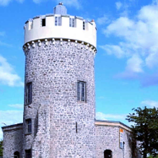
Clifton Observatory

The building was erected, with the permission of the Society of Merchant Venturers, as a windmill for corn in 1766 and later converted to the grinding of snuff, when it became known as 'The Snuff Mill'. This was damaged by fire on 30 October 1777, when the sails were left turning during a gale and caused the equipment to catch alight. It was then derelict for 52 years until in 1828 William West, an artist, rented the old mill, for 5 shillings (25p) a year, as a studio.

In 1977, the Merchant Venturers sold the observatory to Honorbrook Inns; however, they were obliged to maintain public access to the camera obscura whose ownership was retained by the Merchant Venturers.

Suspension Bridge

The idea of building a bridge across the Avon Gorge originated in 1753. Original plans were for a stone bridge and later iterations were for a wrought iron structure. In 1831, an attempt to build Brunel's design was halted by the Bristol riots, and the revised version of his designs was built after his death and completed in 1864. Although similar in size, the bridge towers are not identical in design, the Clifton tower having side cut-outs, the Leigh tower more pointed arches atop a 110-foot (34 m) red sandstone-clad abutment. Roller-mounted "saddles" at the top of each tower allow movement of the three independent wrought iron chains on each side when loads pass over the bridge. The bridge deck is suspended by 162 vertical wrought-iron rods in 81 matching pairs.
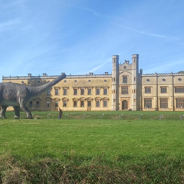
Ashton Court

Ashton Court has been the site of a manor house since the 11th century, and has been developed by a series of owners since then. From the 16th to 20th centuries it was owned by the Smyth family with each generation changing the house. Designs by Humphry Repton were used for the landscaping in the early 19th century. It was used as a military hospital in the First World War. In 1936 it was used as the venue for the Royal Show and, during the Second World War as an army transit camp. In 1946 the last of the Smyth family died and the house fell into disrepair before its purchase in 1959 by Bristol City Council.(wikipedia)


Walking Words
Walking Words
A poetry soundmap of Bristol UK

DOWNLOAD OUR APP TO DISCOVER THIS TOUR AND MANY OTHERS.

play-storeapp-store

The Echoes


The Observatory

Poem by Dave Wynne-Jones

Clifton Suspension Bridge

Poem by David Wynne-Jones

Ashton Court

Poem by David Wynne-Jones

Ashton Court Today

Poem by Dave Wynne-Jones

Space dust

Background music by Finval

Discover more geolocated content in our apps.
play-storeapple-app-store

Or start creating tours, treasure hunts, POI maps... Just let your imagination guide you.


Other walks nearby

Walking Words: Clifton Library to the Observatory via Royal York Crescent

Walking Words: Clifton Library to the Observatory via Royal York Crescent

Poet: Tim Burroughs- Clifton past and present Royal York Crescent The construction started in 1791 but was not completed until 1820. The raised pavement built over vaulted cellars in front of the entire terrace, which is c. 390 metres (1,280 ft) long, Royal York Crescent is reputed to be the longest crescent in Europe. Nos. 1–3 were used until 1855 as a boarding school for girls, run by Mrs Rogers and her four daughters. In 1837 the school was attended by Eugénie de Montijo, the future Empress of the French, and her sister Paca, the future Duchess of Alba.
free
Walking Words: SS Great Britain to Underfall Yard

Walking Words: SS Great Britain to Underfall Yard

Poems by Jo Eades The Underfall Yard was commonly referred to as "The Underfalls" and takes its name from the underfall sluices. The construction was completed in 1809 under the direction of William Jessop and substantially improved by Isambard Kingdom Brunel in the 1830s. In the early nineteenth century the engineer, William Jessop was engaged by the Bristol Dock Company to create a Floating Harbour to eliminate the problem of ships being grounded at low tide. Jessop built a lock to retain the water in the harbour; this was completed in 1809, and allowed ships to remain floating at all times, unaffected by the state of the tide on the river. Part of the project included building a dam at the Underfall Yard with a weir, known as the Overfall, to allow surplus river water to flow into the New Cut, an excavation which by-passed the Floating Harbour and joined the River Avon near Temple Meads. The docks' maintenance facility was established on the land exposed by the damming of the river to construct the harbour, and remains sited at this location to the present day. By the 1830s the Floating Harbour was suffering from severe silting and Isambard Kingdom Brunel devised the underfall sluices based on William Jessop's original plans and recommended the use of dredgers as a solution.
free
Walking Words: SS Great Britain

Walking Words: SS Great Britain

Poet: Marie Papier SS Great Britain is a museum ship and former passenger steamship that was advanced for her time. She was the largest passenger ship in the world from 1845 to 1854. She was designed by Isambard Kingdom Brunel (1806–1859), for the Great Western Steamship Company's transatlantic service between Bristol and New York City. While other ships had been built of iron or equipped with a screw propeller, Great Britain was the first to combine these features in a large ocean-going ship. She was the first iron steamer to cross the Atlantic Ocean, which she did in 1845, in 14 days. The ship is 322 ft (98 m) in length and has a 3,400-ton displacement. She was powered by two inclined two-cylinder engines of the direct-acting type, with twin high pressure cylinders (diameter uncertain) and twin low pressure cylinders 88 in (220 cm) bore, all of 6-foot (1.8 m) stroke cylinders. She was also provided with secondary masts for sail power. The four decks provided accommodation for a crew of 120, plus 360 passengers who were provided with cabins, and dining and promenade saloons. When launched in 1843, Great Britain was by far the largest vessel afloat. But her protracted construction time of six years (1839–1845) and high cost had left her owners in a difficult financial position, and they were forced out of business in 1846, having spent all their remaining funds refloating the ship after she ran aground at Dundrum Bay in County Down near Newcastle in what is now Northern Ireland, after a navigation error. In 1852 she was sold for salvage and repaired. Great Britain later carried thousands of emigrants to Australia from 1852 until being converted to all-sail in 1881. Three years later, she was retired to the Falkland Islands, where she was used as a warehouse, quarantine ship and coal hulk until she was scuttled in 1937, 98 years after being laid down.
free
Walking Words: The Wills Building to RWA via Triangle

Walking Words: The Wills Building to RWA via Triangle

A walk from the Wills building via the Triangle to RWA and Victoria Rooms. Poet: Jim Sidgwick RWA The Royal West of England Academy was the first art gallery to be established in Bristol, and is one of the longest-running regional galleries and art schools in the UK. Its foundation was initiated by the extraordinary Ellen Sharples, who secured funding from benefactors including Isambard Kingdom Brunel and Prince Albert, and the building was ultimately financed by a bequest of £2,000 from her will in 1849. At first, the core of the Academy was a well-known group of artists in Bristol, known as the Bristol Society of Artists, who were mostly landscape painters, and many, such as William James Müller, Francis Danby, James Baker Pyne and John Syer were well known. In 1844, when the Bristol Academy for the Promotion of Fine Arts was founded, the Bristol Society of Artists was incorporated into it. At this time the president and committee was predominantly its patrons, rather than its artists. In 1913 King George V granted the academy its Royal title, with the reigning monarch as its Patron, and by 1914 a major extension to the front of the building, including the dome and Walter Crane lunettes, was completed. The Victoria Rooms, also known as the Vic Rooms, houses the University of Bristol's music department in Clifton, Bristol, England, on a prominent site at the junction of Queens Road and Whiteladies Road. The building, originally assembly rooms, was designed by Charles Dyer and was constructed between 1838 and 1842 in Greek revival style, and named in honour of Queen Victoria, who had acceded to the throne in the previous year. An eight column Corinthian portico surmounts the entrance, with a classical relief sculpture designed by Musgrave Watson above. The construction is of dressed stonework, with a slate roof. A bronze statue of Edward VII, was erected in 1912 at the front of the Victoria Rooms, together with a curved pool and several fountains with sculptures in the Art Nouveau style.
free
Walking Words: Berkeley Square

Walking Words: Berkeley Square

A walk from Park Street around Berkeley Square. Poet: Charles Thompson Berkeley Square and The Square Bar Berkeley Square was laid out in 1787 by Thomas Paty. The surrounding buildings were only completed in the early 19th century. It is unusual among the Georgian squares of Bristol in that it occupies a sloping site, and this makes the unity of its architecture difficult to appreciate. When Bristol obtained its charter in 1373, the event was marked by the building of a magnificent ‘High Cross’ at the heart of the city. The Cross remained in place for over three centuries, “high, noble, and increasingly inconvenient to traffic”.In 1733 it was moved to College Green, but the residents complained and it was pulled down. In 1762 the Dean of Bristol illegally presented the High Cross to his friend Richard Hoare, who installed it in the grounds of his house at Stourhead in Wiltshire.In the 19th century the city recognised its loss and built a copy of the original cross after a fund raising campaign by the then Dean. It was erected in 1850.However, history repeated itself. The Cross was moved to the Green in 1888 to make way for a statue of Queen Victoria. In 1959 it was taken down to open up the view of the new Council House.The top part was rescued and erected in a corner of Berkeley Square, where it still stands “the kings and queens, sadly gazing at the moss in their laps”. A conversion of a Grade II Listed building from the former YWCA in Berkeley Square to a new high quality hotel with restaurant and en suite bedrooms, together with the creation of “The Square” bar in the basement. The building forms the central feature of a terrace of 8 houses, originally constructed by Thomas and William Paty in the late 18th century and rebuilt following destruction in the second world war. The buildings feature limestone ashlar walls, articulated by giant pilasters to cornice and parapet, with rusticated ground floor, all under under a slated mansard roof.(wikipedia)
free
Walking Words: Wapping Wharf to SS Great Britain

Walking Words: Wapping Wharf to SS Great Britain

Poems by David Punter Bristol Docks In the 18th century, the docks in Liverpool grew larger and so increased competition with Bristol for the tobacco trade. Coastal trade was also important, with the area called "Welsh Back" concentrating on trows with cargoes from the slate industry in Wales, stone, timber and coal.[7] The limitations of Bristol's docks were causing problems to business, so in 1802 William Jessop proposed installing a dam and lock at Hotwells to create the harbour. The £530,000 scheme was approved by Parliament, and construction began in May 1804. The scheme included the construction of the Cumberland Basin, a large wide stretch of the harbour in Hotwells where the Quay walls and bollards have listed building status.[8] Launch of the SS Great Britain, the revolutionary ship of Isambard Kingdom Brunel, at Bristol in 1843 The tidal new cut was constructed from Netham to Hotwells, with another dam installed at this end of the harbour. The Feeder Canal between Temple Meads and Netham provided a link to the tidal river so that boats could continue upstream to Bath. However, the new scheme required a way to equalise the levels inside and outside the Dock for the passage of vessels to and from the Avon, and bridges to cross the water. Jessop built Cumberland Basin with two entrance locks from the tidal Avon, of widths 45 and 35 ft (13.7 and 10.7 m), and a 45-foot-wide (13.7 m) junction lock between the Basin and what became known as the Floating Harbour. This arrangement provided flexibility of operation with the Basin being used as a lock when there were large numbers of arrivals and sailings. The harbour was officially opened on 1 May 1809
free
Walking Words: St.Johns Conduit-Brandon Hill down Park Street to the old city walls

Walking Words: St.Johns Conduit-Brandon Hill down Park Street to the old city walls

Poetry walk following St John's Conduit from St Georges down Park Street and across to the Bristol Beacon. Poet:Martin Rieser St John's Gate St John's Gate, which stands at the bottom of Broad street, is the last remaining part of the city wall, with Church of St John the Baptist built above it. The two side passages were created in the 1820s. Niches in the wall contain the figures Brennus and Belinus, according to legend they founded the city. Nearby St John's Conduit was originally built for the friary of the Carmelites but also supplied the people of Brandon Hill. The parishioners were allowed to use only the overflow from the system, and they took advantage of this again during the blitz of World War II when water mains had been damaged. (wikipedia)
free
Walking Words: Royal Fort to Wills Building

Walking Words: Royal Fort to Wills Building

A walk from the Royal Fort Gardens down to the Wills Building via Bristol Grammar School. Poets: Tony D'Arpino and Elizabeth Parker Royal Fort The house was constructed on the site of a Civil War fortification, which had two bastions on the inside of the lines and three on the outside. It was the strongest part of the defences of Bristol, designed by Dutch military engineer Sir Bernard de Gomme. It was one of the few purpose-built defensive works of the war era. The fort was designed as the western headquarters of the Royalist army under Prince Rupert. Royalists retreated into the fort when the Parliamentarians had broken through the lines in the siege of 1645, before eventually surrendering to Cromwell's forces. The fort was demolished around 1655. The "Royal" in the name was in honour of Prince Rupert, when he was made Governor of Bristol. Gardens Colonel Thomas Tyndall employed Humphry Repton from 1799 to landscape the gardens which form a small part of Tyndall's Park, which extended to Whiteladies Road in the west, Park Row in the south and Cotham Hill to the north.Over the years large parts of the park were sold for housing development, as the site for the Bristol Grammar School, purchased in 1877, and only a small part of the original area remains, as Royal Fort Gardens. The siting of drives in the Royal Fort park is still reflected in street plans today.
free
Walking Words: Museum to Christmas Steps

Walking Words: Museum to Christmas Steps

A short walk from the Bristol Museum and Art Gallery down Park Row to the Christmas Steps. Poems by Gillie Harries The Museum and Art Gallery The Museum and Art Gallery's origins lie in the foundation, in 1823, of the Bristol Institution for the Advancement of Science and Art, sharing brand-new premises at the bottom of Park Street (a 100 yards (91 m) downhill from the current site) with the slightly older Bristol Literary and Philosophical Society. The neoclassical building was designed by Sir Charles Robert Cockerell (1788–1863), who was later to complete the Fitzwilliam Museum, Cambridge, and build St. George's Hall, Liverpool, and was later used as the Freemasons Hall. In April 1871 the Bristol Institution merged with the Bristol Library Society and on 1 April 1872 a new combined museum and library building in Venetian Gothic style was opened at the top of Park Street. Christmas Steps The name comes from the medieval Knifesmith Street. In Middle English the 'K' in 'knife' and 'knight' was sounded. It seems likely 'Knifesmith Street' became corrupted over time to 'Christmas Street'. In William Worcestre's 1480 itinerary of Bristol, he describes it as 'knyfesmythstrete aliter Cristmastrete' The street continued to be recorded as 'Christmas Street' in the official town rentals of the sixteenth and seventeenth centuries. This is also how it is recorded in the Hearth Tax Books of Bristol in the 1660s.Christmas Street still runs from St John's Gate to St Bartholomew's Hospital at the bottom of 'Christmas Steps'.(wikipedia)
free

Are you a creator?

START HERE

Privacy & cookie policy / Terms and conditions

© ECHOES. All rights reserved / ECHOES.XYZ Limited is a company registered in England and Wales, Registered office at Merston Common Cottage, Merston, Chichester, West Sussex, PO20 1BE

v2.4.29 © ECHOES. All rights reserved.