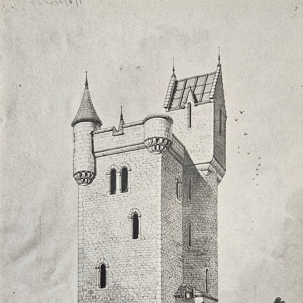
The road here from Clandeboye House was carefully designed by James Frazer in 1852 to entice visitors as they progressed through the shade of woodlands and open vistas across the parks, with occasional peeps of the tower beckoning from the horizon.
Eventually, in the words of Harold Nicholson in 1937: “The road winds up to it through the woods that [Lord Dufferin] planted, and as one reaches the summit there is a gleam of light among the undergrowth and a sudden clearing upon which the tower rises slim and strong”.[1]
Nicholson then went on to describe the smell of the caretaker’s rabbit stew and potato cakes that permeated the building, for in those days the tower was a popular destination, attested by visitor books spanning the years from 1904 to 1953.[2]
The architect was William Burn, who also designed the gatehouse at Killyleagh Castle. His 1848 sketch depicted the tower looking a little bleak on the hill-top, but as the trees grew around, so did the magic. Just as with the journey through the park, the journey up the stone turret stairway, glancing through doors into heavily decorated and panelled rooms with peeps through narrow windows into the trees, draws the visitor ever onwards to the journey’s end. In Nicholson’s words again: “Up a final short flight of steps to the roof-bastion, with its sweep of sky around the battlements and the rush of the winds from Scotland. Below, tumble the green fields and white cottages of Ulster and at one’s feet the woods and lakes of the Clandeboye demesne”. [3]
The building work was completed in 1850, as the 24-year-old Dufferin noted in his diary: “Arrived at Clandeboye, found my tower and lodge built. Tower looks less well from ye house than any other position, but ye effect is upon the whole excellent.”[4] A couple of weeks later: “Miss Hamilton christened the tower by ye name of Helen’s Tower & champagne went all over her.”[5] She may well have been the young Hariot Rowan Hamilton, from Killyleagh Castle, whom Dufferin was to marry as an eighteen-year-old in 1862. Helen was Dufferin’s mother, who was herself only eighteen years older than him.
Benjamin Ferrey, who designed Helen’s Bay station, was engaged to oversee the interior works, even helping to choose furniture.[6] Dufferin’s diaries record the progress of the work, with the glass windows installed in 1856.[7] It must have been difficult to complete the work in these damp conditions as the agent had to install two patent stoves, which were kept burning during wet weather and windows open[ed] in easterly winds, all of which proved to be beneficial.[8]
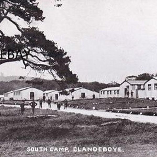
The stories of the tower are personal to so many, from soldiers training for the battle of the Somme, to tea with Prince Charles and Lady Dufferin, presided over by Robbie John Cousins, her butler, with a huge silver tea-pot, and hopefully there will be many more.
[1] Harold Nicholson, Helen's Tower (London: Constable and Co Ltd, 1937), 138.
[2] PRONI D1231/G/5
[3] Nicholson, Helen's Tower, 141.
[4] PRONI D1071/H/V/1/5 (2 October 1850)
[5] Ibid (20 October 1850)
[6] PRONI D1071/H/V/1/11 (4 December 1855)
[7] PRONI D1071/H/V/1/12 (17 January 1856)
[8] PRONI D1071/A/K/1/B/6/1 (12 January 1857)