Ballysallagh Minor
1 sound
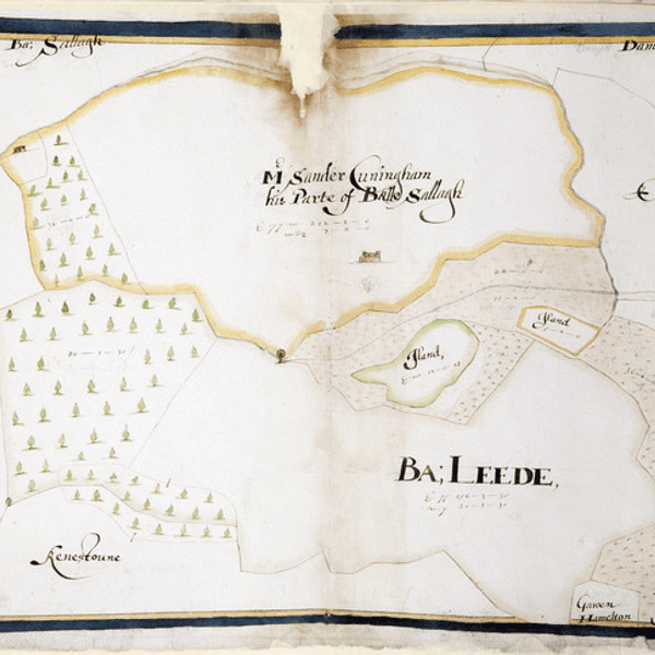
In this furthest southern corner of the townland of Ballysallagh Minor a small, thatched cottage once stood in a woodland clearing. Thomas Raven marked it on his map of the Hamilton estates in 1626 and drew it in the style of an Irish cabin, without even a chimney. The townland was then occupied by Mr Sander (as in Alexander) Cuningham.[1] His house was about one and a half miles downstream from here, on the far side of the Ballysallagh Road. The house, as drawn by Raven, was stone built with two windows on either side of a central front door and first floor dormer windows. Although the house is long gone, a clump of trees once marked the site, although it too has now disappeared under the plough.
Attempts by Queen Elizabeth in the 1570s to push the O’Neill clan out of this part of Ulster through plantation by Sir Thomas Smith had proved disastrous, resulting in scorched earth tactics by O’Neill and ensuing English retribution. The result was that for the following thirty years, until the Hamilton plantation began in 1606, the land was depopulated, wasted and desolate. So Cuningham could have been the first person for over thirty years to occupy the townland, except maybe for the occupants of the Irish cabin.
Alexander Cunningham had purchased the land from Sir James Hamilton on 28th November 1615. The area was noted as 12 score and 12 acres after the usual measure of Scotland, which would equate to about 320 acres today, and the rent was £8 current money of England.[2]
The next recorded transaction included the purchase of Ballywooly, Ballygrott, Ballyskelly and Ballysallagh by the Blackwood family in 1726, as they began to extend their estate.[3] The Blackwoods had purchased the adjoining townland of Ballyleidy in 1674 and constructed their own plantation style house, complete with an avenue leading up from the main road; so maybe the Cuningham house was surplus to requirements, demolished and the stone used for other building projects. This was common practice, but it is ironic that the cabin that stood here remained until at least 1834, out of sight and out of mind.
By the 1850s, when James Frazer began designing the extensive new landscape, it finally succumbed when Lord Dufferin decided in 1857 to join this woodland to the Cairn wood, thus creating a continuous belt of woodland along the southern boundary of his estate that linked the two hill tops dominated by Helen’s Tower at one end and the ancient hill fort of Cairngavar at the other.[4] Certainly, at that time, Lord Dufferin was quite used to demolishing cottages on the estate, in the name of progress.[5] And maybe it was a little past its best after two centuries of habitation.
[1] Raven Map 1626, on display in the North Down Museum [2] Landed Estates Court. Estate of Earl of Dufferin. Statement as to Titles to land comprised in conditional order for declaration of title (privately held) [3] ibid [4] PRONI D1071/A/K/1/B/6/1 (6 February 1857) [5] PRONI D1071/A/K/1/B/6/1 (22 May 1857)
