Chronicles - Walk 3

6 ECHOES

Location: Bangor, Ards and North Down, Northern Ireland, United Kingdom

John Witchell
John Witchell

This walk follows the Columban Way for about 1.6 miles along the wooded Clandeboye avenue and a country lane, linking the A3 Bangor to Belfast Dual Carriageway with the Ballysallagh Road. There is no parking on the Ballsallgh Road so I suggest parking on the A3 where the avenue crosses it. Be very careful when crossing the road on foot.

Soundtrack: Orchestral Scherzo by Daniel Williams

Belfast Gate Lodge

In order for the avenue to cross the Ballyrobert Road and the Crawfordsburn Road, Lord Dufferin had bridges built to go respectively under and over, but here there was no such option, so he decided to build a gate lodge.

The Belfast Lodge was designed by Benjamin Ferrey in 1855. He had also designed Helen’s Bay station, but whereas the station was Baronial Gothic, this building was to be Tudor Revival, built in brick, with dressed stone features and mullioned windows. The front door was sheeted with cast iron studding and a Tudor archway over which is a sculpted panel containing a coronet.[1]

Sadly, the lodge was sold during one of the estate’s many periods of austerity during the last century. The brickwork is now painted over, and the house half hidden behind a high fence.

The main estate entrance is now beyond the traffic lights towards Bangor. Prior to 1960, it was the site of what was another fine Tudor Revival style gate lodge, but it was demolished when the dual carriageway was constructed and replaced by a mundane modern bungalow. The Bangor Gate Lodge was designed by William Burn in 1849 and was larger than this one, with one and a half stories, and set back from the original road with walls sweeping in towards the gates.[2] William Burn also designed Helen’s Tower.

Benjamin Ferrey, as well as designing the station and the Belfast lodge, also offered his opinion on earlier projects, evidenced by a memo to Dufferin suggesting alterations in the chimney of the Bangor Lodge and an additional fireplace above the stairs, to prevent smoke and heat the house better - and also the position of the gate to enable carriages to be seen more readily coming from Bangor. He then went on to suggest that the windows in his own Belfast lodge should be replaced by casements, and finally suggested that low parapet walls - a short distance along the road, at both sides & each end, should be built onto the bridge, or tunnel as he called it, over which the avenue enters the park on the Crawfordsburn Road.[3] The bridge that today prevents the passage of high vehicles onto the Craigantlet hills.

Dufferin later sought Ferrey’s advice in finding a garden designer. He first suggested Mr Page from Southampton but then recommended William Kemp, a very practical man who had worked with Paxton at Birkenhead Park.[4] It was Kemp who planned the Pinetum, whose magnificent trees pierce the skyline as you drive along this dual carriageway from Bangor towards Clandeboye. It may have been good for commuters, but not for the historic landscape that it cut through.

[1] J. A. K Dean, The Gate Lodges of Ulster (Ulster Architectural Heritage Society, 1994), 69.

[2] Dean, The Gate Lodges of Ulster, 69.

[3] PRONI D1071/A/K/03/B/02/1 (November 1861)

[4] PRONI D1071/A/K/03/B/02/1 (20 February and 2 March 1863)

1 sound

Canada

The various woods in this section of the Clandeboye avenue reflect Lord Dufferin’s time as Governor General in Canada, between 1872 and 1878. Names of woods include Montreal, Tadousac, Toronto, Niagara and Ottawa. There is no trace in the archive of a diary written by him during this period but his wife, Hariot, wrote a wonderful diary, later published under the title of "My Canadian Journal” in which she describes in detail the family’s time there.

On arrival in Canada, Lord and Lady Dufferin proceeded to the Governor’s house in Ottawa, obviously a bit of a let-down after the initial ceremonies in Quebec. To quote from her journal: “We have been so enthusiastic about everything hereto that the first sight of Rideau Hall did lower our spirits just a little! The road to it is rough and ugly, the house appears to be at the land’s end, and there is no view whatever from it,..”[1] They soon settled in and started work on improvements to the house, making room for their five children and staff. By the time they left in 1878 they had added two more children to the family, as well as grand additions to the house, including a ballroom and indoor tennis court that doubled up as a supper room at balls by installing a tent inside it. The tent room today is a far grander affair than the original, and definitely no longer for tennis.[2]

Having started on the Ottawa residence, Dufferin turned his attention to Quebec, where he moved into the officer’s mess on the Citadel and created yet another ball room. But their greatest love was for Tadousac, at the confluence of the Saguenay and St Lawrence rivers, regularly visited by many breeds of Whale, including the white Beluga.[3]

The family visited Tadousac shortly after arriving in Canada and fell in love with it. They initially stayed in the hotel, which was popular with American visitors, but Lord Dufferin soon purchased a plot overlooking the beach for $1 and a local timber firm was engaged to build a large summer house for them.[4] This was to be the summer home for the children while their parents travelled throughout the country, by whatever means available, including canoes, trains, steamers, carriages and even in wagons across the prairie. As the representative of the Queen, and even though his office was next door to the Prime Minister’s, Lord Dufferin had to resist the temptation to involve himself in politics and therefore decided that the best course of action to encourage the union of the country was to entertain as many Canadians as he could, hence the ball rooms. However, only by reading her journals could you get a full flavour of these wonderful days in their lives together.

[1] Harriot Georgina Blackwood Dufferin and Ava, My Canadian Journal 1872-'78 (D. Appleton & Co, 1891), 4.

[2] https://www.youtube.com/watch?v=KXy3e9BdtXk

[3] https://www.nhm.ac.uk/discover/beluga-whales.html

[4] Dufferin and Ava, My Canadian Journal 1872-'78, 13.

[5] Barbara Jane Messamore, "'The line over which he must not pass': Defining the Office of Governor General, 1878," The Canadian Historical Review 86, no. 3 (2005).

1 sound

The Concrete Pillar

You shouldn’t have to look too carefully to find a concrete bollard beside the footpath just ahead of you, but it might take a leap of your imagination to guess why it is here. Maybe it will soon become obvious as I tell its story.

As long ago as 1946 plans were put in place to improve the road systems approaching Belfast. These were updated and added to in 1964 with a plethora of proposed motorways, including extending the proposed M3 to Bangor. The plans were reviewed in 1969 and the M3 was amongst those considered to be a realistic option for completion by 1986. Luckily for the precious landscape that we are walking through, the project was quietly abandoned in the late 1980s, but not before this post had been erected to mark its route across the countryside.

The M3 was to have been an extension of the dual carriageway that heads for Clandeboye from Bangor and then bears right by the cemetery. The proposal was that it would carry straight on, across the front drive into the Clandeboye estate and onwards through the Craigantlet hills to Redburn. Lord and Lady Dufferin were appalled at the proposition and decided to plant trees on either side of the front drive, with the help of local school children and even Tom King, the then Secretary of State. Their plan was to elicit local support to protect the trees if the motorway plans were to go ahead.

Had this road scheme been devised in the eighteenth century, the estate would have been successful in preventing this, because at that time new roads were not allowed to pass through planted walks or an avenue to any house. Nor could they pass through fields enclosed by walls higher than five feet. This may have been the reason that Lord Dufferin approached his neighbour Mr Ward of Bangor Castle in 1809, explaining that he wished to build his estate wall across the land of one of his tenants and proposing a land swap for a farm in Ballyholme to accommodate it. This went ahead, and the deed was signed in 1815. So Lord Dufferin was able to build his wall, presumably over five feet high, and soon after that a new road was built around the outside of the estate, linking the Belfast Road to the top of the Clandeboye Road. This road was later moved, when the Clandeboye lake was extended in 1886, and replaced by the Rathgael Road.

But back to the present: Just be thankful, as you walk past this insignificant concrete pillar, that you are not trying to cross the M3 to Bangor.

[1] www.wesleyjohnston.com/roads/motorwayhistory.html

[2] J T Fulton, "The Roads of County Down 1600-1900: The evolution of the road system of an Irish county" (Queen's Belfast, 1972), 46, 52.

[3] PRONI D1071/H/V/1/34 (14 November 1809)

[4] PRONI D4216/2/4/19 (12 January 1815)

1 sound

The Mill Brook

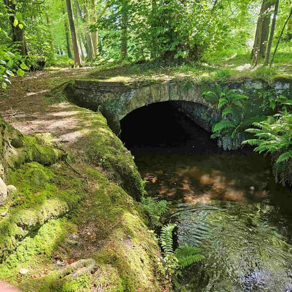
You will need a lot of patience to play poo sticks here. This beautifully built tunnel that carries the Mill Brook below us was just a small part of the civil engineering works employed to create the Clandeboye Avenue.

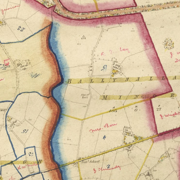
The Mill Brook rises in the hills around the Cairn Wood, from where a number of streams now feed into the Ballysallagh reservoirs before continuing their journey to the sea in the Crawfordsburn Country Park.

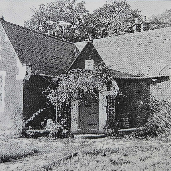
Prior to its use as a water supply to North Down, this was an important source of power. There were two flax mills on the estate section, one upstream and one downstream of here. The upstream mill, on Millbrook Lane, was marked on the first edition of the OS map in 1834, but was gone by the 3rd edition in 1904. The other mill, just downstream of here, did not survive until the 1862 edition and was probably a casualty of James Frazer’s 1850 landscape plans. There was a third mill on the land of Craigdarragh House, by Helen’s Bay, which Lord Dufferin purchased from Mr Gordon in 1861,[1] however it was dismantled in 1865 and re-assembled at Carrickmannon.[2] We must therefore assume that the manager that Lord Dufferin appointed in 1865 would have been for the Millbrook mill.[3]

Growing flax was obviously a precarious business, as evidenced by Dufferin’s agent, Mortimer Thompson, in a letter to him in 1853, saying “it is nothing more than a gambling transaction with our farmers”.[4] However, by this time Ulster’s linen industry had grown so large that much of the flax was imported, mainly from Russia. The rise of the linen industry grew from the demise of cotton after the Napoleonic wars, but the defining moment was on 10th June 1828 when Thomas Mulholland’s York Street cotton mill was burnt to the ground. He rebuilt it, not for spinning cotton, but flax, using a system of wet spinning, developed at their Francis Street mill. The new factory had three steam engines, driving 15,300 spindles.[5]

The irony of this story lies in Lord Dufferin’s excessive landscaping schemes, including this avenue, for by 1872 it was none other than John Mulholland who had lent him £120,000 of his eye watering £299,000 debts, and who was not willing to reduce the interest below 4%.[6] Dufferin was almost insolvent and was even willing to sell Clandeboye to clear his debts, but eventually sold only his outlying estates around Killyleagh and on the Ards peninsula, leaving him with 5,000 of his 18,000 acres. Luckily for him, Mulholland obtained the Ards estate, which was adjacent to his own country seat, Ballywalter Park, the ownership of which obviously obviated any social need for him to buy Clandeboye House and its demesne.[7] It was indeed a close-run thing.

[1] PRONI D1071/H/V/1/19 (17 November 1861)

[2] PRONI D1071/A/K/1/B/14/1 (30 January 1865)

[3] PRONI D1071/H/B/M/341/2

[4] PRONI D1071/A/K/3/B/1 (19 June 1853)

[5] Jonathan Bardon, A History of Ulster (Blackstaff Press, 1992), 261.

[6] Annie Tindley, Lord Dufferin, Ireland and the British Empire, C. 1820-1900 (Routledge, 2021), 39.

[7] PRONI D1167

1 sound

Tenant farms

This lane was one of many that criss-crossed the countryside in the nineteenth century. The Griffiths Valuation of about 1862 identifies two farms along its length.[1] Robert Finlay rented 103 acres and James Barr rented 42 acres. Note the large fields, which are still much the same as they were then and tell the story of Lord Dufferin’s lifelong quest for land improvement in Ireland.

In 1847, whilst a student at Oxford University, the young Lord Dufferin had heard about the failure of the potato crop in Ireland the previous year and the ensuing stories of starvation and decided to investigate for himself by travelling to Skibbereen. He was appalled by what he saw and later wrote that “Dead bodies had lain putrefying in the midst of the sick remnants of their families, none strong enough to remove them, until the rats and decay made it difficult to recognize that they had been human beings”.[2]

That winter he also visited all of the tenant farmers on his 18,000 acres and concluded, in an address to them in August 1848 that, although confounded by what he had seen, he was never despairing. He reflected that nothing could resist time, management, and education; and that improvement, “once in progress acquires itself an innate power of motion, and if not in this, at all events in the next generation, the whole tone of people’s habits might be raised. Such, gentleman, is the kind of work that Irish landlords have now on their hands”.[3]

The combination of his experiences of Skibbereen and the tour of his estate left an indelible mark on Dufferin’s future career, as he witnessed discordance between landlords and their tenants on his travels across the empire. Meanwhile, he had misgivings about the Ulster Custom of land letting, which although ensuring security of tenure, also entitled an outgoing tenant to charge the incoming tenant for the improvements that he had made, thus depriving the landlord of any real interest in his own land. Dufferin was convinced that the tenant’s improvements should be the responsibility of the landlord, who should reimburse his tenant before agreeing a new rent with the incoming tenant. This would encourage the Landlord to take an active part in improving his own land and ensure good husbandry. He also advocated for arbitration if agreement could not be reached.[4]

Whilst Dufferin spent a small fortune creating his avenues and parks, he also spent large amounts proving his point by improving his land and amalgamating let farms whenever possible, even winning an award for his programme of drainage. Also, and to the despair of his land agent, he persisted in offering rent rebates, despite annual rent arrears of over £2,000. So, as the coffers emptied, by 1872 he had reluctantly decided to sell off all his let farms except those closest to Clandeboye, leaving him with a mere 5,000 acres, and many fewer headaches.[5] However, it is heartening to see from estate maps that the same families still rented these two farms for at least another thirty years.

[1] www.askaboutireland.ie/griffith-valuation/ [2] Harold Nicholson, Helen's Tower (London: Constable and Co Ltd, 1937), 71.

[3] Sir Alfred Lyall, The life of the Marquis of Dufferin and Ava (London: Thomas Nelson & Sons, 1905), 62.

[4] Lyall, The life of the Marquis of Dufferin and Ava, 154.

[5] Andrew Gailey, The Lost Imperialist (London: John Murray, 2015), 116.

1 sound

Ballysallagh Road

This is the Ballysallagh Road. Although not on Raven’s 1626 map,[1] it was marked on Taylor and Skinner’s map of the Roads of Ireland in 1777, connecting Bangor across the Craigantlet hills to Dundonald.[2] The section that passed to the South of what was then Ballyleidy House (now Clandeboye House) was shown on Sloane’s map of the Blackwood lands in about 1712.[3] More to the point, it probably existed as far back as 1674, when John Blackwood purchased Ballyleidy from the Hamiltons of Killyleagh, and built the first iteration of the house, complete with an avenue leading from the road.

Further evidence of the early existence of the road arises from a tale that was relayed to me by the late Charlie Williamson, who managed the farm between the 1950s and 1980s. We were walking in the woods one day and he pointed out a very large Beech tree near the lake to the East of the house. “Marshall Schomberg tied his horse to this tree” he said, with apparent confidence. Later research showed that the old road did run past that tree, and furthermore that in 1689, Schomberg sent many of his 10,000 troops along this road to camp in the Craigantlet hills overlooking Belfast. Although he set up his headquarters in Newtownards, it is quite possible that he did use this route to visit his troops.[4] There is even a house on the hills called Schomberg’s cottage.

The reason that I did not realise that the road once went past Schomberg’s tree was that it had been realigned further from the house sometime in the late eighteenth century. Then, in 1852, James Frazer drew the outline of a lake in front of the house on his map of the new landscape plan, but he also drew the line of a new road that skirted it. When Lord Dufferin finally started work on the lake in 1865, he abandoned the idea of a new road in favour of diverting traffic around the estate completely, thus removing access through his demesne. However, his tenants from this part of the estate were not at all pleased at this development and set off to Downpatrick to appeal to the Grand Jury to stop the project. Dufferin’s agent, Mortimer Thompson, got wind of this and followed them. On catching up with them, their spokesman, Mr Gelston, who farmed the land near here, on the Millbrook Lane, explained that the road closure would mean that they could only bring back one load of turf a day from the bogs of the Ards peninsula, instead of two. So, Thompson arranged compensation to allow for this inconvenience and the closure was accordingly accepted.[5] Hence the sharp bend in the road as you travel towards Bangor from here.

[1] On display in the North Down Museum

[2] Taylor and Skinner, Maps of the Roads of Ireland. Surveyed 1777 (1778), Map 6.

[3] PRONI T3666/1

[4] PRONI D1071/B/B/19/1

[5] PRONI D1071/A/K/1/B/14/1 (9 March 1865)

1 sound

DOWNLOAD OUR APP TO DISCOVER THIS TOUR AND MANY OTHERS.

play-storeapp-store

Or start creating tours, treasure hunts, POI maps... Just let your imagination guide you.


Other walks nearby


Are you a creator?

START HERE

Privacy & cookie policy / Terms and conditions

© ECHOES. All rights reserved / ECHOES.XYZ Limited is a company registered in England and Wales, Registered office at Merston Common Cottage, Merston, Chichester, West Sussex, PO20 1BE

v2.5.15 © ECHOES. All rights reserved.